|
|
|
GLENDORA’S BRODIAEA FILIFOLIA
Past - Present - Future
by
Dick Swinney
copyright June 1991
partially revised October 2007
Also on the subject by author:
Sensitive Areas of The Eastern San Gabriel Mountains
Glendora Brodiaea Preserve
copyright 2005
Table of Contents
Introduction
I. History of the Preserve Site
II. Plant Species List for the Glendora Brodiaea Preserve
III. Description of Brodiaea filifolia
IV. Glendora’s Populations of Brodiaea filifolia
V. Floristic Studies on the Glendora Site
VI. A Research Summary of Known Brodiaea filifolia Populations
VII. Communication Between the State and the City of Glendora
INTRODUCTION
Glendora’s best kept secret made a timely debut creating newspaper headlines in 1989 that read:
“Endangered Plant Changes Face of Project” - Glendora Press; July 26, 1989
“Endangered Plant Puts Development in Danger” - San Gabriel Valley Tribune; 1989
“Glendora Hillside-Home Plan Delayed”: - Steve Scauzillo; February, 1989, San Gabriel Valley Tribune
Many contradictory and misleading statements were made concerning the Thread-leaved Brodiaea in the myriad of articles that summarized the stormy controversy over the proposed development of Glendora’s “Colby Site”. In this paper, the confusion surrounding the true identity and the actual status of this endangered plant will be dealt with so as to yield a more accurate presentation. Because of the public interest this plant generated by its role in the “Colby Controversy”, this paper is written to inform the public of the facts behind the scenes of the Brodiaea filifolia and the land it occupies.
I The Glendora Brodiaea Preserve Site
The area in question occupies a 3.4 acre plateau at approximately 1200 feet elevation at the north end of Loraine Ave. in Glendora, California. The plateau is defined by “Colby Canyon” on the east and a canyon of similar dimension cutting its west flank. The Colby Road or Fallow Motorway passes through “Colby Canyon” and is designated for enlargement to accommodate the impending housing development.
The plateau is dissected steeply on portions of three of its flanks; the west, east and so;south. The north end of the plateau rises gently up a south-facing ridge of the San Gabriel Mountain foothills. The southern end of the plateau overlooks the coalesced alluvial fans of the Glendora basin.
The soil of the site is fine-grained, dark to red and of a clay consistency. This site was originally part of a 160 acre homestead occupied in the 1880’s. The plateau was first cleared in the early 1900’s by the Colby family, the second owners of this property. Lemon orchards were planted on several of the flat areas of the Colby Ranch including the Brodiaea Site. Ray Bloker purchased the property in the 1950’s and became its third owner. Bloker ran 100 head of cattle on his ranch. He purchased the calves from the dairies and grazed them until he sold the heifers back to the dairies. The cattle were supposedly grazed on the plateau.
Joe Wagner, a longtime Glendora resident, was caretaker of the ranch during the 1940’s and 50’s. The plateau was disked of weeds for fire abatement until May of 1988. The orchards declined until irrigation was halted in the early 1960’s. Much of the above information was obtained from Bill Cullen.
The enigma of the survival and success of the endangered thread-leaved Brodiaea on this particular site may always remain a mystery. Several facts however are clear.
1. Brodiaea filifolia had previously been recorded in the Glendora area.
2. Some Brodiaea managed to survive the years of disking, lowing, irrigating and cattle grazing. This is true unless some Brodiaea were transplanted here at some point in time after the earlier soil disturbance.
3. The presence of nearly one thousand Brodiaea by 1991; has definitely been enhanced by the artificial maintenance of this site. The high percentage of ground coverage by the surrounding native plant communities would not likely yield the high numbers of this species as seen today. Most known locations of this species offer grassland or coastal sage-scrub plant community habitats. The last thirty years of disking has created and maintained an artificial grassland community.
The property was purchased by Everett Hughes in 1975. The present plans for the property include a housing development project. Because of the interest generated by the discovery of the Brodiaea on the plateau site, Mr. Hughes agreed to transfer 3.4 acres of the plateau to the City of Glendora. The city would eventually like to turn the “Preserve” over to another interested institution. The official transfer of this property to the City of Glendora has not yet taken place and is being further complicated by the pending sale of part of the Hughes-owned Bloker Site property to another party.
II Glendora Brodiaea Reserve Plant Species List
* = non-native species
1. Achillea millefolium L.
var. californica (Pollard) Jeps. Milfoil, White Yarrow
*2. Anagalus arvensis L. Scarlet Pimpernel
*3. Anthemis cotula L. Mayweed
4. Artemisia californica Less. Coastal or California Sagebrush
*5. Avena barbata Brot. Slender Wild Oat
*6. Brassica rapa (L.) Field Mustard
7. Brodiaea filifolia Wats. Thread-leaved Brodiaea
*8. Bromus diandrus Roth. Ripgut Grass
*9. Bromus hordiaceus L. Soft Chess
*10. Bromus madritensis L.
ssp. rubens L. Husnot Foxtail Chess
*11. Centaurea melitensis L. Yellow Star Thistle
12. Centaurium venustum
(A. Gray) Robinson Canchalagua
13. Chamaesyce albamarginata
(Wheeler) Koutnik Rattlesnake Weed
*14. Erodium cicutarium (L.) L’Her. Red-stem Filaree
*15. Erodium brachycarpum
(Godron) Thell Short-fruited Filaree
16. Hazardia squarrosa
(Hook. & Arn.) E. Greene Saw-toothed Goldenbush
17. Helianthus annuus L.
ssp. lenticularis (Douglas) Cockerell Common Sunflower
18. Hemizonia fasciculata (DC.)
Torrey & A. Gray Fascicled Tarweed
*19. Hirschfeldia incana (L.) Lagr.-Fossat Shortpod Mustard
*20. Hordium murinum L. ssp. leparinum
(Link) Arcang. Foxtail Barley
*21. Hypochaeris glabra L. Smooth Cat’s Ear
*22. Lactuca seriola L. Wild or Prickly Lettuce
23. Lessingia filaginifolia Cudweed Aster, California Aster
(Hook & Arn.) M.A. Lane
*24. Malacothrix saxatilis (Nutt.) Torrey
& A. Gray var. tenuifolia (Nutt.) A. Gray Cliff Malacothrix
*25. Marrubium vulgare L. Horehound
*26. Mellilotus indica(L.) All. Yellow Sweet Clover, Sourclover
27. Nassella pulchra (A. Hitchc.)
Barkworth Nodding Needlegrass
*28. Picris echioides L. Bristly Ox Tongue
29. Piptatherum miliaceum (L.) Cosson Smilo Grass
30. Quercus agrifolia Nee Coast Live Oak
*31. Rhaphanus sativus L. Wild Radish
*32. Rumex crispus L. Curly Dock
*33. Silybum marianum (L.) Gaertner Milk Thistle
*34. Sonchus oleraceus L. Common Sow Thistle
*35. Verbascum blattaria L. Moth Mullein
*36. Vulpia myuros L. C. Gmelin
var. hirsuta Hacakel) L Asch.
& Graebner Hairy Rat-tail Fescue
The following plant species are currently encroaching on the margins of the plateau.
37. Eriogonum fasciculatum Benth.
ssp. foliolosum (Nutt.) Abrams California Buckwheat
38. Eriophyllum confertiflorum (DC.)
A. Gray var. confertiflorum Golden Yarrow
39. Melica imperfecta Trin. Chaparral Melica
40. Opuntia littoralis (Engelm) Coast Prickly Pear
41. Toxicodendron diversilobum
(Torrey & A. Gray) E. Greene Poison Oak
The following plant species are growing under two Quercus agrifolia trees on the plateau. Both trees are less than 15 feet high.
42. Heteromeles arbutifolia
(Lindley) Roemer Toyon, Christmas Berrry
43. Lonicera subspicata Hook. & Arn.
var. denudata Rehder Southern Honeysuckle
44. Rhamnus ilicifolia Kellogg Holly-leaf Redberry
45. Rhus integrifolia (Nutt.)
Brewer & S. Watson Lemonadeberry
The six most abundant plants in numbers as determined by casual observance were:
Avena barbata
Bromus hordiaceus
Bromus madritensis ssp. rubens
Centaurea melitensis
Hirshfeldia incana
Vulpia myuros
The three plant species that seemed to have the highest percentage of ground cover were:
Avena barbata
Bromus hordiaceus
Centaurea melitensis
For reference to plant species found in the area surrounding the plateau, see Glendora Foothills Pant Checklist - San Gabriel Mountains , Dick Swinney, 1994.
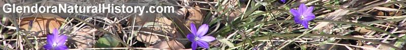
III Description Of Brodiaea filifolia
It is a member of the family Liliaceae to which also belong the cultivated Amaryllis, onions, garlic and daffodills. It belongs to a small genus native to Pacific North America. There are only six species of Brodiaea currently recorded in southern California. One new species was described in 2007 by Tom Chester.
The genus Brodiaea was named after the Scottish botanist J. J. Brodie. The species name filifolia literally means thread-leaved. The apparent closest relative to Brodiaea filifolia is Brodiaea orcuttii. It was previously listed as a variety of B. filifolia by Willis Linn Jepson: B. filifolia Wats. var. orcuttii Jepson. On casual glance, the two species are very similar. B. orcuttii was later separated as a distinct species by Baker.
The flower color of both species is violet. B. orcuttii has slender filaments 4-6 mm. long while B. filifolia has triangular shaped filaments only 1 mm. long. B. filifolia has staminodia (sterile stamens) while B. orcuttii does not. Both species often occur together in the populations further south. Both plants generally grow in heavy clay soils near vernal pools.
Another native perennial herb often called a Brodiaea is the Wild Hyacinth. This plant is very common throughout southern California and occurs in the native vegetation near the plateau of the “Glendora Site”. This plant has been placed in several different genera by plant taxonomists over the years. It is now called Dichelostema pulchella. For many years it had remained in the genus Brodiaea. The Wild Hyacinth generally begins blooming two or three months before the Thread-leaved Brodiaea. The Glendora population of B. filifolia has been near the peak of its blooming season during mid May in the years 1989, 1990, and 1991.
The following description of Brodiaea filifolia is recorded in “ A Flora of Southern California” by Philip A. Munz. University of California Press; Berkeley; Los Angeles, London, 1974.
B. filifolia Wats. (Hookera filifolia. Greene.) Scape 2-4 dm. high; lvs. several, shorter than or nearly as long as scapes, 1-2mm. wide; pedicels 2-5 cm. long; perianth violet, the tube greenish, narrow-companulate, 6-7 mm. long, membranous and splitting in fruit; segms. spreading 9-12 mm. long; staminodia plane linear, 6,7 mm. long when fresh, much shorter in dry flowers, curved outward above; filaments 1 mm. long, triangular; anthers. 4 mm. in heavy clay soil below 200 feet; Coastal Sage Scrub, Chaparral; Glendora, San Bernardino V., Perris, Vista. May-June.
Literature search of all known populations of B. filifolia indicates they have been found in the following habitats: Semi-alkaline mudflats (Perris), vernal pools, valley and foothill grasslands, coastal-sage scrub (San Bernardino County), and disturbed soil with weedy plant species. The habitat for the Glendora population of 1921 was not indicated on the herbarium specimen sheet. The single specimen I found in Glendora May 9, 1970 was in a mixed chaparral/coastal-sage scrub plant community.
IV Glendora’s Population Of Brodiaea filifolia
This plant is listed as occurring in Glendora by Philip A. Munz and David D. Keck in A California Flora, 1965 and in the manual by Munz A Flora of Southern California, 1974. It is not listed by Jepson in his A Manual of the Flowering Plants of California, 1925.
The California Natural Diversity Data Base (CNDDB) of the State of California Department of Fish and Game (DFG) showed only one reference to the Glendora population. The data base search that I requested on B. filifolia was made on February 9, 1990. The DNDDB reports the following information for the Glendora location:
Collector: H. Davidson, M.D.
Date: May, 1921
Location: Glendora
T 1N R 10W
Lat: 34d 08m 19s
Long: 117d 51m 18s
QUAD: Glendora
Cat #: 3418 - California Academy of Sciences, Botany Department Herbarium, San Francisco Elv. 840 feet
From a phone conversation with staff at the Herbarium of the California Academy of Sciences, I learned that Cat. # 3418 is the only specimen of B. filifolia representing the Glendora population at the herbarium. The herbarium specimen has no elevation recorded and no further information listed than what appeared on the CNDDB, 1987. If the elevation recorded by CNDDB is correct, it was apparently obtained from a source other than the data label for Cat. # 3418. A 1936 California state survey found B. filifolia to be absent from Glendora.
In December of 1987, three B. filifolia plants were observed in Glendora in a vegetative condition by Ty Garrison. Garrison observed these during an initial survey of the Hughes property for an environmental impact report (E.I.R.) in December of 1987. He dug up the three plants and removed them to his private residence in Glendale. The plants bloomed in the spring of 1988. They were identified by Fred Roberts, Howie Wier, and Michael Brandamn of the University of California at Irvine.
Mr. Garrison was a project biologist for the Newport Beach based Planning Center. He now operates his own business, Biological Assessment Services. In the spring of 1988, he identified and tagged twenty-seven plants in bloom at the “Glendora Site”. Because of fear of potential injury to the plants, Garrison removed these and others which finally totaled 286 plants. This was done in 1988 prior to and after the planned disking of the site as ordered by the L.A. County Fire Department. Garrison collected many Brodiaea bulbs that were laying on the surface of the ground after the disking. Annual disking of this site had taken place for over thirty years after the removal of lemon trees. No consultation was made with any state agency or other organizations concerned with the protection of state endangered species concerning the removal of these plants.
An article by Steve Scauzillo from the San Gabriel Valley Tribune reported the following in February of 1989:
Susan Cochrane, Coordinator of the Endangered Plant Program at the State Department of Fish & Game said, “Garrison took the plants without first consulting her department, a technical violation.: But Garrison defended himself saying his actions were necessary to save them after fire crews “disked” the grassland where the Brodiaea were living. “Several had been cut in half or were just laying on the surface,” he said. Garrison said the Sacramento Fish & Game office did not comment on the E.I.R. at all. Cochrane confirmed this, blaming heavy workloads for the oversight. She said Garrison “acted in good faith,” but added, “we would’ve liked to have known this was going on.”
In a personal conversation with Ty Garrison in December of 1989, he told me that none of the 286 plants kept at his home had died. Garrison’s estimation of 800 B. filifolia plants reported in at least one newspaper article stemmed from his 1988 observation of 240 plants on the site plus his 286 plants at his home. He arrived at the estimation from the percentage of bulbs at his home that bloomed in 1988 in relation to the total number of plants at his home. He then correlated this information to the number he observed blooming on the site. The February 1989 newspaper quotes of 800 Brodiaea being observed on the site by Garrison are therefore incorrect.
I visited the site in May of 1989 and counted approximately 230 plants in bloom. I again visited the site on March 21, 1990. At that time, most of the basil leaves seemed to be growing as they were near full average size. The surrounding herbacious species (mostly grasses) were not yet tall enough to obscure easy observation of the Brodiaea plant leaves. A total 660 plants were counted on the site. Thirty-eight plants were counted south of the road. Plants were found growing near the margins of the plateau on all four sides.
In May of 1990, I again visited the site and counted 870 plants in bloom. During blooming, most of the basil leaves were brown and in the process of withering and were often difficult to see. The surrounding grassy vegetation (mostly Avena sativa) towers above the Brodiaea at this time. On May 18, 1991, I counted 961 Brodiaea on the site. Two-hundred and fifty-five plants were observed blooming north of the east-west pathway while 706 plants were observed blooming south of the path. Many scapes (flower stalks) counted did not yet have any flowers in bloom. On June 1, 1991, I made a study to determine the percentage of Brodiaea (producing scapes) to actually be in bloom on that date. The results showed that 55 percent of the flowers had already bloomed. This study is presented in chapter V of this paper.
In preparation for the Glendora Foothills Plant Checklist, I reexamined plant specimens I had collected many years previous. Many of ;the plants had not yet been identified. One plant was identified in September of 1989 to be B. filifolia. It was identified by Andrew Sanders, Curator of the Herbarium at the University of California at Riverside. This plant is currently in the herbarium collection at U.C.R. along with hundreds of other plants I have collected for the Glendora Foothills Pant Checklist.
This plant was the only B. filifolia I found during my survey of the 1968 burn area in the north Glendora foothills. This study took place from 1968 to 1975. This fire did not reach the Brodiaea Site of the current study as the fire stopped at the fire break on the east side of Easley canyon, approximately 600 yards to the west. The blooming plant was found on the “Bender” property on May 9, 1970. Its catalog number is 740 in my personal collection. This location is approximately one-half mile north of Sierra Madre in Glendora at the north terminus Pennsylvania Avenue. This is nearly one and two tenths miles west of the Colby Brodiaea Site. The elevation at both sites approximately 1200 feet.
Years following the discovery of the B. filifolia on the “Bender Site”, the property was sold to Lavey Smith and has since been resold to Robert Hughes and is currently being developed. The location of the lone plant was immediately south of the housing sites at the eastern end. The site was made up of components of the coastal sage scrub, chaparral and southern oak woodland plant communities. No further B. filifolia have been found at this location. I have not revisited the “Bender Site” since 1975. At the time of collection of this plant, it was not yet listed as an endangered species. B. filifolia was adopted by the State of California as an endangered species in 1982.
V. Floristic Studies On The Glendora Site
A. On June 1, 1991, I made a study to determine the percentage of B. filifolia in bloom on that date. Thirty-two flower scapes were examined. All scapes selected had nine or more pedicels (flower stalks). By using this method, a relatively large number of pedicels could be examined using a minimum number of scapes (plants.) The scapes were randomly selected with exception to pedicel number. The following data was collected:
1. Number of pedicels per scape
2. Number of withered pedicels per scape.
3. Number of pedicels with fruit per scape.
4. Number of pedicels with flower per scape.
5. Number of pedicels with bud per scape.
Data:
Maximum number of pedicels per scape = 26
Maximum number of pedicels per plant in flower = 4 (same plant as above)
Total number of pedicels = 415
Total number withered after blooming - 21
Total number in fruit - 207
Total number in bloom - 67
Total number in bud - 120
Results:
Average percentage of withered pedicel per scape = 5.1%
Average percentage of fruited pedicels per scape = 49.9%
Average percentage of buds per scape = 28.9%
Average percentage of flowering pedicels per scape = 16.1%
Percentage of pedicels past bloom (withered pedicels after blooming and fruited pedicels) = 55%
Percentage of pedicels flowering or in bud = 45%
Thus on June 1, 1991, 55% of all B. filifolia sampled had completed blooming. The populations were just past the peak of their blooming season.
B. On June 8, 1991, I made a study to determine the following:
1. Average scape height.
2. Average maximum pedicel heights (in fl. or frt.)
3. Average number of pedicels per scape.
4. Average number of pedicels in flower per scape.
The plants were randomly selected throughout the site.
Data:
Total number of scapes surveyed = 40
Total number of pedicels = 341
Total scape heights = 1,394.7 cm.
Total pedicel heights = 209.8 c.
Total number of pedicels in flower = 49
Results:
Average number of pedicels per scape = 8.53 = 9
Average height of scapes = 34.9 cm.
Average maximum height of pedicel per scape = 5.3 cm.
Average number of pedicels in flower per scape = 1.2 = 1
C. On June 89, 1991, the scape recording the greatest height from June 1 was measured again.
Date June 1 June 8
Scape Ht. 73.3 cm. 82.5 cm.
Max. Pedicel Ht. -- 8.9 cm. (in fl.)
# Pedicels 26 30
# Pedicels in flower 4 3
# Pedicels withered 1 2
# Pedicels in fruit 4 11
# Pedicels in bud 17 14
The maximum scape and pedicel heights recorded in this study greatly exceed the ranges listed for this species by Munz’ 1974 A Flora of Southern California.
VI. A Research Summary Of All Known Brodiaea filifolia Populations
October 2007 revision includes latest information on Glendora Populations only.
The following information was obtained from the CNDDB of the California Department of Fish and Game from a search I requested dated February 9, 1990. Information regarding the extant Glendora populations is provided by myself and Garrison. One additional listing from the California Academy of Sciences in San Francisco was also obtained. Further information may have been added to the data base program after this search request was made.
A total of 25 populations have been recorded all from southern California. No known populations exist in Mexico, other states or on California off-shore islands. The only recorded populations now considered to have been erroneous was the San Clemente Island report. This population is Brodiaea kinkiensis according to Beauchamp, 1980.
The following reported populations are now considered to be possibly extinct (extirpated):
Los Angeles County
1. Glendora
Lat: 34d 08m 19s
Long: 117d 51m 18s
QUAD: Glendora
T IN R 10W Fraction of Merid S
Foothills N. of Glendora
Last observed: May 1921
Plant specimen in the herbarium of the California Academy of Sciences (CAS), San Francisco.
Collector: Davidson, H. M. D.
Cat. # 3418
Elevation of 840 feet listed by CNDDB but not present on specimen # 3418. This was perhaps computed by CNDDB from Lat. and Long. coordinates. In applying these coordinates to the 1966 Glendora quadrangle, I also located a position at 840 feet. The location is the vicinity of the Mt. View and Live Oak junction in Glendora north of Foothill The range coordinate is inconsistent with the long. given. If the long. is correct, the range should be corrected to 9W. There is no 10W. on the 1966 Glendora Topographic Map. 10W. is on the Azusa quad.
San Bernardino County
2. Arrowhead Hot Springs
QUAD: San Bernardino north
Hills at Arrowhead Hot Springs
San Bernardino Mountains
Elv. 1680 feet
Last seen: 1919, May 17, Spencer, M.F.
Cat. # 1139, CAS Herbarium
3. Arrowhead Springs Road
QUAD: San Bernardino north
One mile from Hotel, San Bernardino Mountains
Elv. 40l00 feet
Last seen: 1953, April, Stone, B.
Cat. # 317, SD Herbarium
Riverside County
4. Perris data from CAS, San Francisco
QUAD: Perris
1 mile north of Perris
Last seen: 1930, Moons & Johnson
Habitat: Heavy alkaline soil
5. Perris
QUAD: Perris
Two miles S. of Perris
Elv. 1410 feet
Last seen: 1930, Howell, J.T.
Cat. # 4790, CAS Herbarium
6. East of Perris
San Jacinto River Bottom
QUAD: Perris
Elv. 1400 feet
Last seen: 1952, Roos, J.C.
Cat. # 5667, CAS Herbarium
Habitat eliminated by agriculture; once common
San Diego County
7. Vista
East of S. Melrose Ave. (Sec. 36)
QUAD: San Luis Rey
Elv. 400 feet
Last seen: April 1977
Some transplanted to area just south of original site. This population is not doing well(1983, Armstrong). Other plants transplanted at Brengle Terrace Park and Carriage Hills Estate.
The following population are considered to still be extant (present):
Los Angeles County
1. Glendora
QUAD: Glendora
T 1N R 9W Sect. 19
Foothills of San Gabriel Mountains
1/2 mile N. of Sierra Madre Ave., north of the north terminus of Pennsylvania Ave.
Collector: Dick Swinney
Swinney’s Cat. # 740
U.C.R. Cat. # ?
Date collected: May 9, 1940
Last seen: May 9, 1970
Only one plant was found.
Plant community: coastal sage scrub and chaparral, ridge top
Soil type: dark, non-clay soil
Future of site: recent housing development
Elv.: 1200 feet
Site not revisited since 1975. Location observed between 1970 and 1975.
Identification: Andrew Sanders, Herbarium Curator, U.C.R.
2. Glendora
QUAD: Glendora
T 1N R 9W Section 20
Location: Foothills of the San Gabriel Mountains, approximately 313 yards north of the north terminus of Loraine Ave. on the Fallow Motorway (Colby Rd.). The site is approximately 15 yards west of ;the Fallow Motorway and is currently protected by a fence and gate at the entrance.
Soil: Fine-grained, reddish
First observance: Ty Garrison, Project Biologist, Planning Center, Newport Beach
Date of First Observation: December 1987
Condition of population: Preliminary data suggest population is expanding. Last count by Dick Swinney on May 18, 1991 yielded 961 plants on the site. See chapter IV of this report for further details
Plants in private ownership: Mr. Garrison removed 387 plants in 1988 to his private residence in Glendale. Most plants removed were due to fear of damage during disking of weeds on the site.
Request to return Brodiaea plants to Glendora site: The DFG has requested the bulbs be returned to the site in Glendora
Source of request: Letter dated March 15, 1990 by Susan A. Cochrane, Chief of the Natural Heritage Division, DFG.
Plant Identification: Fred Roberts, Howie Wier, Michael Brandamn, U.C.I.
Owner protecting: Yes; transfer of ownership to the City of Glendora is currently in progress.
Protective Measures: a. City of Glendora is taking measures to comply to recommendations made by Fish & Game. See chapter VII of this report. b. Establishment of the Glendora Brodiaea subcommittee under the direction of the Glendora Trails Committee. The Trails Committee was established by the Glendora Community Services Commission. Subcommittee members: Ann Croissant, PhD, Jerry Croissant, PhD, Dick Swinney, Ty Garrison (Consultant), Orlando Mistretta (Consultant).
Last observation: Studies ongoing
Population: studies at this site: See chapter V of this report.
Habitat: 3.4 acre plateau, formerly the site of lemon orchard and cattle grazing. Last disked in May of 1988. Forty-five species of plants (mostly on-native) have been identified on this site by the author. See chapter II of this report. Site is now a grassland community of mostly naturalized species. Original plant communities were most likely chaparral, coastal sage scrub and southern oak woodland. These are the communities immediately surrounding the site.
Elv.: 1200 feet
3. Glendora
QUAD: Glendora
T 1N R 9W Section 20
Location: Approximately. 30 meters south of Glendora Mountain Road on Fallow Motorway (Colby Rd.) north of city boundary. Property owned by Hughes Development.
Condition of motorway: dirt surface
Soil: Fine-grained, reddish, similar to site # 2 of this report for extant populations.
Distance from population # 2: 300 m. to the N.E.
Habitat: Disturbed area on both sides of Colby Trail. Site consists of approximately 25 square meters at junction of Colby Trail and Fire break at approximately 25 meters south of Glendora Mountain Road. Periodically cleared of vegetation.
First observance: Jack Mason & Dick Swinney observed independently within one week period, May 1990.
Specimens collected: none
Condition of population: Approximately 40 seen in 1989, 11 seen in May 1991 by author, no observations in 1990.
Future of site: Possible road modification and brush removal
Elv. 1720 feet
Identification: Dick Swinney
4. Glendora (Lower Bluebird - Eastern populations - listed as 3 separate populations by Fisher)
QUAD: Glendora
T 1N R 9W Section 27
Location: Approximately 0.3 miles north-east of Morgan Canyon Debris Basin in Glendora. It is east of the east fork of Morgan Canyon and immediately adjacent to it.
Description: This previously disturbed area (likely disked), had a jeep road passing through the middle of the western margin of the plateau from north to south. The entire area was set aside as open space as a result of mitigation with the CSDFG. This was due to the discovery of B. filifolia by Ty Garrison who who conducted the Environmental Impact Report for the owners of the Guard Ranch Property. John Gordon oversaw the project and made this concession as mitigating circumstances to keep the area of high concentration of Brodiaea preserved.
The southern portion of this site is owned by NJD. whose plans for development of this area has been denied by the City of Glendora.
One of the upper sites for development (east of the plateau) had a much smaller population of this species. Mr. Gordon was given permission to develop this through concession of the lower “Morgan Plateau” area.
As of May 1, 2005, the upper eastern flat area has been graded and all the B. filifolia were destroyed by earth removal. I took a census of this area on May 14, 1992. I counted two-hundred and thirty-two Brodiaea as well as several Calochortus splendens and Calochortus plummerae . They were mostly in full bloom at that time.
Habitat: Grassy plateau surrounded by coastal age-scrub and chaparral.
Special Conditions: A “jeep” trail previously ran through the western portion. This area has been dedicated as private “open space” as part of the mitigation with the developer relating to the presence of B. filifolia. The dominant plants are naturalized grasses.
Elv.: 1500 - 1750 feet
Ownership: John Gordon and property owners association
Further reference: Sensitive Areas of the Eastern San Gabriel Mountains -
Plateaus - “Morgan Plateau”, Dick Swinney, May 2005; an inventory of plants of the site is given as well as determinations of B. filifolia densities.
Observations:
June 21, 1991; May 15, 1992; April 17, 2001; April 19, 2005; April 30, 2005
5. Glendora ( Lower Bluebird population - east of main population, listed as 2 separate populations by Fisher)
North and South populations listed here as one population, as the two populations were probably a single combined population before disking and soil displacement, seperated only by 50 meters.
QUAD: Glendora
T 1N R 9W Section 27
Location: South of Ferguson Motorway and immediately adjacent to it, approximately 200 meters north of boundary between NJD and Gordon property on Ferguson Motorway, near San Dimas boundary.
Special conditions: Previoulsy disked for uncertain number of years.
Mr. Gordon was given permission by DFG to develop this area because of Gordon’s concession of the lower adjacent plateau area (# 4 above) as a plant reserve for the preservation of the B. filifolia.
Description: Weedy grassland species mostly Avena barbata
Plant density: May 14, 1992 - 232 plants
Habitat: Disturbed area
Elv.: 1850 feet
Ownership: John Gordon and property-owners association
6. Glendora (Upper Colby population A by Fisher)
All information obtained from Richard Fisher on October 13 and 14, 2007 from phone conversations and maps.
QUAD: Glendora
T 1N R 9W Section 20
Location: 800 meters north of junction of Glendora Mountain Road and Colby Trail, on the west side of Glendora Mountain Road, 100 yards west of the road on ridge.
Habitat: Coastal-sage scrub, chaparral, Nasella pulchra grassland
Identification: Michael C. Long and Rick Fisher
Ownership: Glendora Conservancy
Plant density: estimated at near 2500 plants
First observance: Richard Fisher and Michael C. Long
Specimens collected: none
Last seen: Spring 2006
Elv.: 1830 feet (center of site)
7. Glendora (Upper Colby population B by Fisher)
All information obtained from Rick Fisher on October 13 and 14, 2007 from phone conversations and maps
QUAD: Glendora
T 1N R 9W Section 20
Location: Approximately 100 meters yards north of population # 6 on ridge west of Glendora Mountain Road.
Habitat: Coastal-sage scrub and chaparral
Identification: Michael C. Long and Richard Fisher
Ownership: Glendora Conservancy
Plant density: Estimated at near 50 plants
First observance: Michael C. Long and Rick Fisher
Specimens collected: none
Last seen: Spring 2006 by Rick Fisher
Elv.: 1830 feet (center of site)
8. Glendora (Lower-Western Bluebird population by Fisher)
All information obtained from Rick Fisher on October 13 and 14, 2007 from phone conversations and maps
QUAD:
T 1N R 9W Section 28
Location: East Glendora foothills in the Bluebird Hills area. Approximately 270 meters west of Mull Canyon and 65 meters south of the Ferguson Motorway. Habitat: Disturbed area, along dirt motorway, surrounded by coastal-sage scrub and chaparral
Identification: Richard Fisher
Ownership: John Gordon
Plant density:
May 2005 - 15 plants
May 2006 - 5 plants
First observance: Richard Fisher
Specimens collected: none
Last seen: Spring 2005 by Richard Fisher
9. Glendora (Upper Bluebird population - main population by Fisher)
All information obtained from Richard Fisher on October 13 and 14, 2007 from phone conversations and maps.
QUAD: Glendora
T 1N R 9W Section 22
Latitude:
Longitude:
Location: East Glendora foothills in the Bluebird Hills area. Approximately 300 meters south of Bluebird Truck Trail and 340 meters west of Morgan Canyon.
Habitat:
Identification: Richard Fisher
Ownership: Ferguson Family
Plant density: 50 plants
Elv.: 2230 - 2340 feet
10. Glendora (Upper Bluebird population - 2nd population by Fisher)
All information obtained from Richrd Fisher on October 13 and 14, 2007 from phone conversations and maps.
QUAD: Glendora
T 1N R 9W Section 22
Latitude:
Longitude:
Location: 30 feet north of Bluebird Truck Trail and approximately 330 meters north of population # 9
Habitat:
Identification: Richard Fisher
Ownership: Ferguson Family
Plant density: 2 plants
Last seen:
Elv.: 2370 feet
Riverside County
11. Santa Rosa Plateau
QUAD: Wildomar
Pool C2 on Mesa De Colorado, Santa Rosa Plateau, one-half mile east of Calle Collima
Condition of plants: several thousand plants
Last seen: May 1988
Elv. 1960 feet
Owner protecting: Yes, the California Nature Conservancy
12. Santa Rosa Plateau
QUAD: Wildomar
Pool C4, Santa Rosa Plateau Reserve
Condition of plants: Several thousand in 1981, Cochrane S.
Last seen: May 1981
Elv. 1960 feet
13. Santa Rosa Plateau
QUAD: Wildomar
3 miles north of Murrieta
Last seen: 1966
Elv. 1800 feet
14. Santa Rosa Plateau, Murrieta
QUAD: Wildomar
4 miles west of Murrieta
Population condition: Unknown
Last seen: 1966, Lathrop, Earl
Elv. 1800 feet
Probably not within Preserve boundary. Natural open space in 1979.
San Diego County
15. Rancho Santa Fe
QUAD: Rancho Santa Fe
S.E. corner of junction between La Costa Ave. and Rancho Santa Fe Rd., N.W. of Rancho Santa Fe.
Population condition: This once vigorous occurence damaged by adjacent development.
Last seen: May 1986
Elv.: 300 feet
16. San Marcos
QUAD: San Marcos
Corner of La Mirada Dr. and Pacific St.
Population condition: 1000 in 1986
Last seen: May 1986
Elv.: 540 feet
17. Vista
QUAD: San Marcos
4.5 miles south of Vista on Hwy. 395 (along road paralleling railroad)
Population condition: Unknown
Last seen: May 19, 1936, Gander, F.
Elv.: 560 feet
18. Vista
QUAD: San Marcos
Brengle Terrace Park
Population condition: Transplanted from Vista population (# 9 above) in 1983.
Last seen: Unknown
Elv.: 600 feet
19. Carlsbad
QUAD: San Marcos
2.5 miles north of Carlsbad Drag strip
Population condition: 1-2 per meter on about 10 acres. Threatened by urbanization.
Last seen: 1980, Armstrong
Elv. 500 feet
20. Carlsbad
QUAD: San Marcos
Just north of Carlsbad Drag strip
Population condition: 1-2 per meter on 5-10 acres.
Last seen: 1980, Armstrong
Elv.: 460 feet
21. Vista
QUAD: San Luis Rey
1/2 mile E.N.E. of Landes Park near Vista.
Population condition: 1-2 per meter on 1-2 acres. Threatened by urbanization.
Last seen: 1980, Armstrong
Elv. 300 feet
22. Palomar
QUAD: San Luis Rey
Claypits just north of Palomar Airport.
Population condition: Abundant on less that 100 acres of weedy grassland.
Last seen: 1980, Armstrong
Elv.: 260 feet
23. San Marcos
QUAD: San Marcos
0.7 miles N.WN. of Palomar College
Population condition: Good, Armstrong
Last seen: 1980, Armstrong
24. Buena
QUAD: San Marcos
T 12S R 3W S 99 Franction of Merid. S
0.6 miles S.S.E. of Buena, near Mission Rd. and railroad tracks.
Population condition: 1-2 per meter; residential area; threats include urbanization.
Last seen: 1980, Armstrong
Elv.: 480 feet
VII. Communication Between The State And The City Of Glendora
The following represents a synopsis of the majority of communications between the State of California Department of Fish & Game and the City of Glendora regarding the status of B. filifolia in Glendora as of June 1991.
1. Initial correspondence to the DFG concerning the discovery of B. filifolia on a Glendora housing development site, correspondence by Ty Garrison of the Planning Center of Newport Beach in 1988.
2. Correspondence by Ann Croissant PhD, Azusa Pacific University, to the DFG. She expressed concern over the status of B. filifolia in Glendora. She requested direction by the DFG to the City of Glendora. Ann requested that one of their members be present at the Planning Commission meeting on March 21, 1989.
3. Delayed response by the DFG to the Planning Center’s initial report on the B. filifolia discovery. The DFG did not respond within the prescribed time limit as required by state law. This fact technically nullified any legal action by the state agency regarding improper treatment of B. filifolia in Glendora.
4. Representatives of DFG attended the Glendora Planning Commission meeting on March 21, 1989. John Fischer and other DFG members answered questions that had been raised at past public hearings and addressed present concerns of planning commission members and staff of the City of Glendora. John conveyed the desires of the DFG that Glendora’s population of B. filifolia be protected.
5. A letter was sent to the City of Glendora by Susan Cochrane, Chief of the Natural Heritage Division of the DFG. She stated that it was the Department’s desire that the B. filifolia which had been removed by Ty be returned to the original site in Glendora. The letter was written by request of myself to give the City of Glendora direction concerning this issue.
6. I contacted Ann Howald of the DFG via phone conversation on March 27, 1990. Ann is the Departments Endangered Plant Ecologist. She requested that I forward the content of her message to the City in the form of a letter. A copy was sent to Ann for her records. The content dealt with the Department’s views on future weed abatement on the site, proximity of trails on the site and perimeter fencing of the site.
7. John Fischer of the DFG attended the June 25, 1990 meeting of the Glendora Trails Committee. John was asked to express the Department’s view regarding the issue of trail access on the Brodiaea Site. John requested that the trail not follow the present dirt roadway through the center of the plateau. This road should be allowed to return to natural conditions.
John requested that the tentative plans for a trail on the west side of the site be terminated if a significant number of B. filifolia were found growing in its projected course. Members present asked John to define the word significant in terms of numbers of Brodiaea, but he stated he could not do that at this time.
All members present agreed that the Brodiaea Site must be carefully inventoried during the following blooming period in 1991. In response to the return of Garrison’s Brodiaea plants to the site, John mentioned that he would prefer that they be relocated to another site. I mentioned tha the City had been directed by Susan Cochrane to return them to the site. John was unaware of that directive. He said he would check with the Department and respond back to the City.
8. During the spring of 1991, Garrison, Ray Ferris and myself surveyed the western edge of the plateau and set visible markers. I recorded locations of the plants in March in their vegetative condition. This was done to assure that those plants which did not bloom were accounted for. City staff, Garrison and members of the Trails Committee met on June 19, 1991 to directly observe the tagged plants. A decision was made as to the exact location of the trail to skirt the western perimeter of the Brodiaea plateau. No B. filifolia will be disturbed. The DFG was notified as to the City’s decision.
9. Reba Cutting of the Glendora City Planning Department had two phone conversations with John Fischer during the spring 1991. John explained that due to a number of reasons, the Department would not be able to be directly involved with the Glendora site in the future. The DFG would like to receive written correspondence from the City to keep them informed of significant decisions made concerning Glendora’s B. filifolia population. Reba stated she will seek to confirm John’s remarks via official correspondence from the DFG.
10. John Fischer has not responded back to the City of Glendora in response to the return of the B. filifolia plants to their original location. As of June 17, 1990, the City is still awaiting a response from John regarding the clarification of the directive by Susan Cochrane to return the Brodiaea plants removed by Ty Garrison. I discussed the return of the Brodiaea plants with Garrison June 19, 1991. He is planning on returning the plants to Glendora at the onset of the next rainy season.
Note: All B. filifolia were eventually taken to the Rancho Santa Ana Botanic Garden in Claremont California by Ty Garrison where they were planted.
|
|